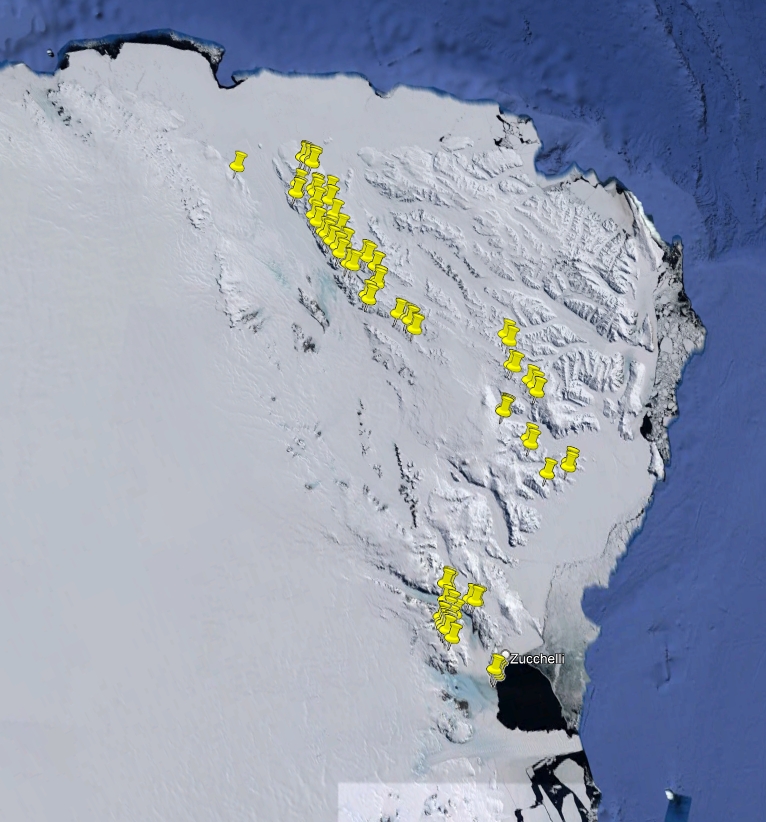
Mariner Glacier
Type of resources
Topics
Keywords
Contact for the resource
Provided by
Years
Formats
Representation types
Update frequencies
status
Scale
-
During the XVIII Italian Antarctic expedition (2002/03), 63 rocks have been sampled within the aim of the project "Geological mapping of Victoria Land" in northern and southern Victoria Land. They include intrusive, subvolcanic, volcanic, metamorphic and sedimentary rocks and sands. The investigated regions are within Convoy Range ST 57-60/1, Freyberg Mountains SS 58-60/1, Mount Joyce SS 55-57/16, Mount Melbourne SS 58-60/9, Reeves Névé SS 55-57/12 and Sequence Hills SS 55-57/8 USGS sheets.
-
During the XXX and XXXI Italian Antarctic expeditions (2014/15, 2015/16), 387 rocks have been sampled within the aim of the project "Tectonic inheritance in northern Victoria Land: the role of Paleozoic discontinuities in recent geodynamic evolution and the influence in the establishment of the Antarctic glaciation" in northern Victoria Land. They include intrusive, subvolcanic, volcanic, metamorphic and sedimentary rocks and fossil woods. The investigated regions are within Coulman Island SS 58-60/6, Daniels Range SR 57-58/14, Ebbe Glacier SR 57-58/16, Freyberg Mountains SS 58-60/1, Mount Joyce SS 55-57/16, Mount Melbourne SS 58-60/9, Mount Murchison SS 58-60/5, Mount Soza SR 57-58/15, Ob' Bay SR 57-58/11, Pomerantz Tableland SR 57-58/10 and Relief Inlet SS 58-60/13 USGS sheets.
-
During the XXVI and XXVII Italian Antarctic expeditions (2010/11, 2011/12), 668 rocks have been sampled within the aim of the project "Geological continental markers of Cenozoic climate changes in Victoria Land, Antarctica" in northern Victoria Land. They include intrusive, subvolcanic, volcanic, metamorphic and sedimentary rocks. The investigated regions are within Cape Hallett SS 58-60/2, Coulman Island SS 58-60/6, Mount Joyce SS 55-57/16, Mount Melbourne SS 58-60/9, Mount Murchison SS 58-60/5 and Relief Inlet SS 58-60/13 USGS sheets.
-

During the XXXIV Italian Antarctic expedition (2018/19), 246 rocks have been sampled within the aim of the project "Early Paleozoic geodynamics of northern Victoria Land and implications for Gondwana reconstructions" in northern Victoria Land. They include intrusive, subvolcanic, volcanic, ultramafic and metamorphic rocks. The investigated regions are within Cape Hallett SS 58-60/2, Coulman Island SS 58-60/6, Freyberg Mountains SS 58-60/1, Mount Melbourne SS 58-60/9, Mount Murchison SS 58-60/5, Mount Soza SR 57-58/15, Ob' Bay SR 57-58/11 and Pomerantz Tableland SR 57-58/10 USGS sheets. Project: Early Paleozoic geodynamics of northern Victoria Land and implications for Gondwana reconstructions.
-
During the XVI Italian Antarctic expedition (2000/01), 284 rocks have been sampled within the aim of the GIGAMAP project in northern and southern Victoria Land. They include intrusive, subvolcanic, volcanic, metamorphic and sedimentary rocks. The investigated regions are within Convoy Range ST 57-60/1, Freyberg Mountains SS 58-60/1, Mount Joyce SS 55-57/16, Mount Melbourne SS 58-60/9, Mount Murchison SS 58-60/5, Reeves Névé SS 55-57/12, Sequence Hills SS 55-57/8 and Welcome Mountain SS 55-57/4 USGS sheets. Project: German Italian Geologic Antarctic Map Program.
-
During the XII Italian Antarctic expedition (1996/97), 553 rocks have been sampled within the aim of the project "Evolution of East Antarctic craton and paleo-Pacific margin of Gondwana" in northern and southern Victoria Land. They include intrusive, subvolcanic, volcanic and metamorphic rocks. The investigated regions are within Cape Hallett SS 58-60/2, Convoy Range ST 57-60/1, Coulman Island SS 58-60/6, Franklin Island ST 57-60/2*, Freyberg Mountains SS 58-60/1, Mount Joyce SS 55-57/16, Mount Melbourne SS 58-60/9, Mount Murchison SS 58-60/5, Mount Soza SR 57-58/15, Ob' Bay SR 57-58/11, Relief Inlet SS 58-60/13, Sequence Hills SS 55-57/8 and Yule Bay SR 57-58/12 USGS sheets.
-
During the IV Italian Antarctic expedition (1988/89), 819 rocks have been sampled within the aim of the project "Regional geology, tectonics, stratigraphy, geological mapping and remote sensing" in northern Victoria Land. They include intrusive, subvolcanic, volcanic, metamorphic and sedimentary rocks. The investigated regions are within Cape Adare SR 59-60/13*, Cape Hallett SS 58-60/2, Coulman Island SS 58-60/6, Freyberg Mountains SS 58-60/1, Mount Melbourne SS 58-60/9, Mount Murchison SS 58-60/5 and Reeves Névé SS 55-57/12 USGS sheets.
-
During the IV Italian Antarctic expedition (1988/89), 1166 rocks have been sampled within the aim of the project "Petrology, geochemistry and metallogenesis of igneous and metamorphic basement" in northern Victoria Land. They include intrusive, subvolcanic, volcanic, metamorphic and sedimentary rocks. The investigated regions are within Cape Hallett SS 58-60/2, Coulman Island SS 58-60/6, Freyberg Mountains SS 58-60/1, Mount Melbourne SS 58-60/9, Mount Murchison SS 58-60/5, Reeves Névé SS 55-57/12, Relief Inlet SS 58-60/13 and Sequence Hills SS 55-57/8 USGS sheets.
-
During the V Italian Antarctic expedition (1989/90), 657 rocks have been sampled within the aim of the project "Regional geology, geological survey and remote sensing" in northern Victoria Land. They include intrusive, subvolcanic, volcanic, metamorphic and sedimentary rocks. The investigated regions are within Cape Hallett SS 58-60/2, Coulman Island SS 58-60/6, Freyberg Mountains SS 58-60/1, Mount Melbourne SS 58-60/9, Mount Murchison SS 58-60/5 and Sequence Hills SS 55-57/8 USGS sheets.
-
During the XX and XXI Italian Antarctic expeditions (2004/05, 2005/06), 668 rocks have been sampled within the aim of the project "Chronologic-dynamic zoning of the Ross Orogen" in northern and southern Victoria Land. They include intrusive, subvolcanic, volcanic, metamorphic and sedimentary rocks. The investigated regions are within Cape Hallett SS 58-60/2, Coulman Island SS 58-60/6, Daniels Range SR 57-58/14, Freyberg Mountains SS 58-60/1, Mount Melbourne SS 58-60/9, Mount Murchison SS 58-60/5, Mount Soza SR 57-58/15, Ob' Bay SR 57-58/11, Pomerantz Tableland SR 57-58/10, Relief Inlet SS 58-60/13, Sequence Hills SS 55-57/8 and Welcome Mountain SS 55-57/4 USGS sheets.