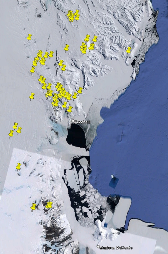
Rocks from the project “German Italian Geologic Antarctic Map Program" (GIGAMAP)
During the XVI Italian Antarctic expedition (2000/01), 284 rocks have been sampled within the aim of the GIGAMAP project in northern and southern Victoria Land. They include intrusive, subvolcanic, volcanic, metamorphic and sedimentary rocks. The investigated regions are within Convoy Range ST 57-60/1, Freyberg Mountains SS 58-60/1, Mount Joyce SS 55-57/16, Mount Melbourne SS 58-60/9, Mount Murchison SS 58-60/5, Reeves Névé SS 55-57/12, Sequence Hills SS 55-57/8 and Welcome Mountain SS 55-57/4 USGS sheets.
Project: German Italian Geologic Antarctic Map Program.
Simple
- Date (Creation)
- 2021-10-01
- Purpose
-
The collection is sorted towards Italian and foreign researchers for geoscience studies.
- Status
- On going
- Maintenance and update frequency
- As needed
-
GEMET - INSPIRE themes, version 1.0
-
-
Geology
-
-
GCMD - Science Keywords
-
-
SEDIMENTARY ROCKS
-
IGNEOUS ROCKS
-
METAMORPHIC ROCKS
-
-
NASA Thesaurus
-
-
glacial drift
-
moraines
-
rocks
-
-
Lithology
-
-
Igneous material
-
Pegmatite
-
Plutonic rock
-
Pyroclastics
-
Amphibolite
-
Arenite
-
Basalt
-
Basaltic rock
-
Breccia
-
Calc-silicate rock
-
Clastic sedimentary rock
-
Dolerite
-
Gabbro
-
Gabbroic rock
-
Gneiss
-
Granite
-
Granitic rock
-
Marble
-
Metacarbonatic rock
-
Metagabbro
-
Metamorphic rock
-
Metasiliciclastic sedimentary rock
-
Mica schist
-
Migmatic rock
-
Migmatite
-
Orthogneiss
-
Phyllite
-
Pyroclastic rock
-
Pyroclastic breccia
-
Pyroxenite
-
Quartzite
-
Sandstone
-
Schist
-
Siltstone
-
Sediment
-
Sedimentary rock
-
Tonalite
-
Volcanic rock
-
Ultramafic rock
-
Limestone
-
Carbonate sedimentary rock
-
Marl
-
Marlstone
-
Claystone
-
-
GCMD - Instruments
-
-
Grabbers/Traps/Collectors
-
-
GCMD - Locations
-
-
ANTARCTICA
-
-
SCAR Gazetteer of Antarctica
-
-
Tobin Mesa
-
Outback Nunataks
-
Brawn Rocks
-
Victoria Land
-
Carapace Nunatak
-
Caudal Hills
-
Deep Freeze Range
-
Brien Rocks
-
Astronaut Glacier
-
Mount Cavaney
-
Eskimo Point
-
Foolsmate Glacier
-
Sheehan Mesa
-
Mount Melbourne
-
Gerlache Inlet
-
Moore Ridge
-
Mackay Glacier
-
Mount Emison
-
Ogden Heights
-
Northern Foothills
-
Mount Levick
-
Retreat Hills
-
Mountaineer Range
-
Priestley Glacier
-
Prince Albert Mountains
-
O'Kane Canyon
-
Random Hills
-
Rennick Névé
-
Mount Joern
-
Mesa Range
-
Mount New Zealand
-
Szanto Spur
-
Sequence Hills
-
Southern Cross Mountains
-
Mount Adamson
-
Agate Peak
-
Black Glacier
-
Battleship Promontory
-
Lister Nunataks
-
Chisholm Hills
-
Intention Nunataks
-
Mount Wood
-
Alatna Valley
-
Eureka Spurs
-
Convoy Range
-
Mount Kring
-
Mount Hewson
-
Priestley Névé
-
Evans Névé
-
Niagara-Eisfälle
-
Mariner Glacier
-
Harrow Peaks
-
Saunders Bluff
-
Reeves Névé
-
Salamander Range
-
Campbell Glacier
-
Capsize Glacier
-
Freyberg Mountains
-
Outpost Nunataks
-
Mount Pedersen
-
The Pleiades
-
Mount Anakiwa
-
Martin Nunataks
-
David Glacier
-
Neall Massif
-
-
GCMD - Providers
-
-
IT/PNRA
-
IT/MNA
-
-
Research Organization
-
-
MNA - Museo Nazionale dell'Antartide
-
- Use limitation
- Creative-Commons CC-BY 4.0
- Association Type
- dependency
- Initiative Type
- Campaign
- Spatial representation type
- Text, table
- Denominator
- 1
- Language
- English
- Character set
- UTF8
))
- Begin date
- 2000-12-04
- End date
- 2001-01-05 Now
- Unique resource identifier
- WGS84
- Distribution format
-
-
XLS
(
1
)
-
KLM
(
1
)
-
XLS
(
1
)
- OnLine resource
-
GeoData
(
WWW:LINK-1.0-http--link
)
Database for the rock samples taken during the PNRA expeditions since the 1985 and preserved at the repository of the Museo Nazionale dell'Antartide.
- OnLine resource
-
Project: GIGAMAP
(
WWW:LINK-1.0-http--link
)
German Italian Geologic Antarctic Map Program
- Hierarchy level
- Dataset
Domain consistency
Conformance result
- Date (Publication)
- 2010-12-08
- Explanation
-
This data set is conformant with the INSPIRE Implementing Rules for the interoperability of spatial data sets and services
- Pass
- Yes
- Statement
-
Samples are stored in cardboard boxes inside metal cabinets in the MNA repository. Samples were weighed, photographed and magnetic susceptibility was measured. Slices were cut to make thin sections.
- File identifier
- f4ed518f-32f8-4238-bd5f-4487cdeb0d59 XML
- Metadata language
- English
- Character set
- UTF8
- Hierarchy level
- Dataset
- Date stamp
- 2024-10-07T09:52:21
- Metadata standard name
-
ISO 19139
- Metadata standard version
-
1.0
Overviews

Spatial extent
))
Provided by
