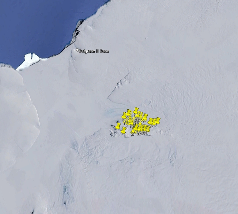
Rocks from the project “International Antarctic Geological Expedition to the Shackleton Range 1994/95" (EUROSHACK)
During the X Italian Antarctic expedition (1994/95), 639 rocks have been sampled within the aim of the international EUROSHACK project in Shackleton Range. They include intrusive, subvolcanic, volcanic and metamorphic rocks. The investigated regions are within Shackleton Range SU 26-30/1* USGS sheet.
Project: International Antarctic Geological Expedition to the Shackleton Range 1994/95.
Simple
- Date (Creation)
- 2021-10-01
- Purpose
-
The collection is sorted towards Italian and foreign researchers for geoscience studies.
- Status
- On going
- Maintenance and update frequency
- As needed
-
GEMET - INSPIRE themes, version 1.0
-
-
Geology
-
-
GCMD - Science Keywords
-
-
IGNEOUS ROCKS
-
METAMORPHIC ROCKS
-
-
NASA Thesaurus
-
-
rocks
-
-
Lithology
-
-
Dolerite
-
Igneous material
-
Plutonic rock
-
Volcanic rock
-
Amphibolite
-
Aplite
-
Diorite
-
Calc-silicate rock
-
Cataclasite
-
Dioritic rock
-
Fault rock
-
Gneiss
-
Gabbroic rock
-
Gabbro
-
Granite
-
Granitic rock
-
Granulite
-
Metagabbro
-
Marble
-
Metabasalt
-
Metacarbonatic rock
-
Metagranite
-
Metamorphic rock
-
Metasiliciclastic sedimentary rock
-
Mica schist
-
Migmatic rock
-
Migmatite
-
Mylonite
-
Orthogneiss
-
Schist
-
Peridotite
-
Phyllite
-
Pyroxenite
-
Quartzite
-
Tonalite
-
Serpentinite
-
Ultramafic rock
-
-
GCMD - Instruments
-
-
Grabbers/Traps/Collectors
-
-
GCMD - Locations
-
-
ANTARCTICA
-
-
SCAR Gazetteer of Antarctica
-
-
Arkell Cirque
-
Baines Nunatak
-
Beche Blade
-
Bernhardi Heights
-
Shackleton Range
-
Bowen Cirque
-
Charlesworth Cliffs
-
Clarkson Cliffs
-
Charpentier Pyramid
-
Blanchard Hill
-
Mount Absalom
-
Bonney Bowl
-
Eskola Cirque
-
Geikie Nunatak
-
Genghis Hills
-
Gordon Glacier
-
Kuno Cirque
-
M'Clintock Bastion
-
Lewis Chain
-
Pointer Nunatak
-
Freshfield Nunatak
-
Fuchs Dome
-
Jamieson Ridge
-
Herbert Mountains
-
Kendall Basin
-
Haskard Highlands
-
Hatch Plain
-
Glen Glacier
-
Lord Nunatak
-
Morris Hills
-
Hollingworth Cliffs
-
Mount Kelsey
-
Mount Sheffield
-
Murchison Cirque
-
Pioneers Escarpment
-
La Grange Nunataks
-
Venetz Peak
-
Poldervaart Edge
-
Read Mountains
-
Shotton Snowfield
-
Mount Beney
-
Stephenson Bastion
-
Slessor Glacier
-
Sumgin Buttress
-
True Hills
-
Watts Needle
-
the Ark
-
Wiggans Hills
-
Högbom Outcrops
-
Whymper Spur
-
-
GCMD - Providers
-
-
IT/PNRA
-
IT/MNA
-
-
Research Organization
-
-
MNA - Museo Nazionale dell'Antartide
-
- Keywords
-
-
metavolcanic rock
-
- Use limitation
- Creative-Commons CC-BY 4.0
- Association Type
- dependency
- Initiative Type
- Campaign
- Spatial representation type
- Text, table
- Denominator
- 1
- Language
- English
- Character set
- UTF8
- Topic category
-
- Geoscientific information
))
- Begin date
- 1994-12-23
- End date
- 1995-02-11 Now
- Unique resource identifier
- WGS84
- Distribution format
-
-
XLS
(
1
)
-
KLM
(
1
)
-
XLS
(
1
)
- OnLine resource
-
GeoData
(
WWW:LINK-1.0-http--link
)
Database for the rock samples taken during the PNRA expeditions since the 1985 and preserved at the repository of the Museo Nazionale dell'Antartide.
- OnLine resource
-
EUROSHACK
(
WWW:LINK-1.0-http--link
)
International Antarctic Geological Expedition to the Shackleton Range 1994/95
- OnLine resource
-
Project: EUROSHACK
(
WWW:LINK-1.0-http--link
)
International Antarctic Geological Expedition to the Shackleton Range 1994/95.
- Hierarchy level
- Dataset
Domain consistency
Conformance result
- Date (Publication)
- 2010-12-08
- Explanation
-
This data set is conformant with the INSPIRE Implementing Rules for the interoperability of spatial data sets and services
- Pass
- Yes
- Statement
-
Samples are stored in cardboard boxes inside metal cabinets in the MNA repository. Samples were weighed, photographed and magnetic susceptibility was measured. Slices were cut to make thin sections.
- File identifier
- dc35f7c4-02db-4216-8634-deb5e52ed21a XML
- Metadata language
- English
- Character set
- UTF8
- Hierarchy level
- Dataset
- Date stamp
- 2024-10-02T14:33:56
- Metadata standard name
-
ISO 19139
- Metadata standard version
-
1.0
Overviews

Spatial extent
))
Provided by
