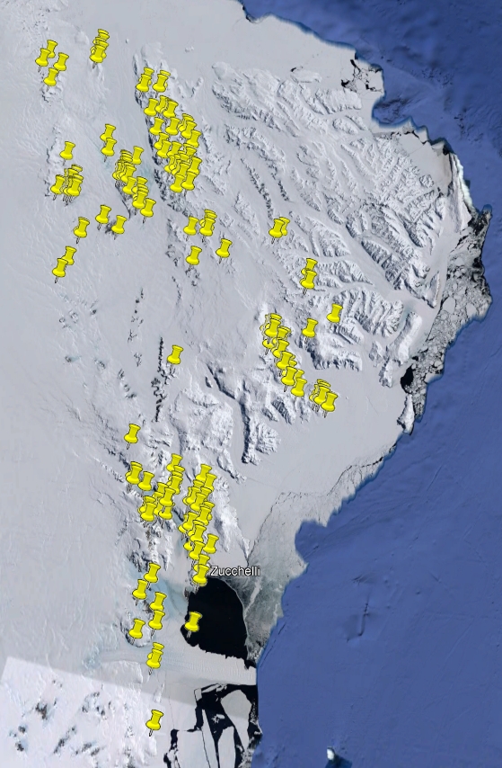
Rocks from the project “Chronologic-dynamic zoning of the Ross Orogen" (PNRA 2004/4.6)
During the XX and XXI Italian Antarctic expeditions (2004/05, 2005/06), 668 rocks have been sampled within the aim of the project "Chronologic-dynamic zoning of the Ross Orogen" in northern and southern Victoria Land. They include intrusive, subvolcanic, volcanic, metamorphic and sedimentary rocks. The investigated regions are within Cape Hallett SS 58-60/2, Coulman Island SS 58-60/6, Daniels Range SR 57-58/14, Freyberg Mountains SS 58-60/1, Mount Melbourne SS 58-60/9, Mount Murchison SS 58-60/5, Mount Soza SR 57-58/15, Ob' Bay SR 57-58/11, Pomerantz Tableland SR 57-58/10, Relief Inlet SS 58-60/13, Sequence Hills SS 55-57/8 and Welcome Mountain SS 55-57/4 USGS sheets.
Simple
- Date (Creation)
- 2021-10-01
- Purpose
-
The collection is sorted towards Italian and foreign researchers for geoscience studies.
- Status
- On going
- Maintenance and update frequency
- As needed
-
GEMET - INSPIRE themes, version 1.0
-
-
Geology
-
-
GCMD - Science Keywords
-
-
IGNEOUS ROCKS
-
METAMORPHIC ROCKS
-
SEDIMENTARY ROCKS
-
-
NASA Thesaurus
-
-
rocks
-
-
Lithology
-
-
Amphibolite
-
Anorthosite
-
Anorthositic rock
-
Aplite
-
Basalt
-
Basaltic rock
-
Biochemical-biogenic sedimentary rock
-
Breccia
-
Calc-silicate rock
-
Cataclasite
-
Chert
-
Clastic sedimentary rock
-
Contact-metamorphic rock
-
Diorite
-
Dioritic rock
-
Dolerite
-
Eclogite
-
Fault rock
-
Fault-related material
-
Gabbro
-
Gabbroic rock
-
Gneiss
-
Granite
-
Granitic rock
-
Granodiorite
-
Granulite
-
High-pressure metamorphic rock
-
Hornfels
-
Marble
-
Metabasalt
-
Metacarbonatic rock
-
Metagabbro
-
Metagranite
-
Metamorphic rock
-
Metasiliciclastic sedimentary rock
-
Mica schist
-
Migmatic rock
-
Migmatite
-
Mylonite
-
Monzonite
-
Orthogneiss
-
Pegmatite
-
Peridotite
-
Plutonic rock
-
Igneous material
-
Porphyroid
-
Pseudotachylite
-
Pyroxenite
-
Quartzite
-
Rhyolite
-
Rhyolithic rock
-
Sandstone
-
Schist
-
Syenitic rock
-
Serpentinite
-
Sedimentary rock
-
Tectonic breccia
-
Tonalite
-
Ultramafic rock
-
Volcanic rock
-
-
GCMD - Instruments
-
-
Grabbers/Traps/Collectors
-
-
GCMD - Locations
-
-
ANTARCTICA
-
-
SCAR Gazetteer of Antarctica
-
-
Victoria Land
-
Alamein Range
-
Adams Ridge
-
Cape Russell
-
Bump Buttress
-
Bowers Mountains
-
Bounty Nunatak
-
Argonaut Glacier
-
Cape Canwe
-
Bier Point
-
Adélie Cove
-
Dorngletscher
-
Cape Sastrugi
-
Boomerang Glacier
-
Frolov Ridge
-
El Pulgar
-
Apostrophe Island
-
Explorers Range
-
Havelgletscher
-
Fingernagelsporn
-
Black Ridge
-
Fleming Head
-
Gateway Hills
-
Graduation Ridge
-
Graveson Glacier
-
Howard Peaks
-
Hunter Glacier
-
Indexsporn
-
Inferno Peak
-
Gair Glacier
-
Kavrayskiy Hills
-
Litell Rocks
-
Lonely One Nunatak
-
Marinerplateau
-
Heuser Nunatak
-
McLin Glacier
-
Molar Massif
-
Monte Cassino
-
Cape Reynolds
-
Jupiter Amphitheatre
-
Mount Burrill
-
Mount Burton
-
Mount Crummer
-
Mount Gow
-
McKenzie Nunatak
-
Mount Pedersen
-
Mount Soza
-
Daniels Range
-
Mount Webb
-
Morozumi Range
-
Dessent Ridge
-
Disthenwand
-
Onlooker Nunatak
-
D'Urville Wall
-
Mount Larsen
-
Emlen Peaks
-
Eskimo Point
-
Foolsmate Glacier
-
Freyberg Mountains
-
Deep Freeze Range
-
Mount Dickason
-
Gerlache Inlet
-
Helliwell Hills
-
Komatsu Nunatak
-
Lanterman Range
-
Mariner Glacier
-
Meander Glacier
-
Millen Range
-
Mount Emison
-
Mount Baxter
-
Mount Meister
-
Mount New Zealand
-
Mount Phelan
-
Mount Queensland
-
Mountaineer Range
-
Nash Ridge
-
Niagara-Eisfälle
-
O'Kane Canyon
-
Mount Levick
-
O'Kane Glacier
-
Northern Foothills
-
Outback Nunataks
-
Mount Toogood
-
-
GCMD - Providers
-
-
IT/PNRA
-
IT/MNA
-
-
Research Organization
-
-
MNA - Museo Nazionale dell'Antartide
-
- Keywords
-
-
metavolcanic rock
-
- Use limitation
- Creative-Commons CC-BY 4.0
- Association Type
- dependency
- Initiative Type
- Campaign
- Spatial representation type
- Text, table
- Denominator
- 1
- Language
- English
- Character set
- UTF8
- Topic category
-
- Geoscientific information
))
- Begin date
- 2004-12-06
- End date
- 2006-01-11 Now
- Unique resource identifier
- WGS84
- Distribution format
-
-
XLS
(
1
)
-
KLM
(
1
)
-
XLS
(
1
)
- OnLine resource
-
GeoData
(
WWW:LINK-1.0-http--link
)
Database for the rock samples taken during the PNRA expeditions since the 1985 and preserved at the repository of the Museo Nazionale dell'Antartide.
- Hierarchy level
- Dataset
Domain consistency
Conformance result
- Date (Publication)
- 2010-12-08
- Explanation
-
This data set is conformant with the INSPIRE Implementing Rules for the interoperability of spatial data sets and services
- Pass
- Yes
- Statement
-
Samples are stored in cardboard boxes inside metal cabinets in the MNA repository. Samples were weighed, photographed and magnetic susceptibility was measured. Slices were cut to make thin sections.
- File identifier
- 76fee4bd-259a-47ee-aef0-8d534c6badf2 XML
- Metadata language
- English
- Character set
- UTF8
- Hierarchy level
- Dataset
- Date stamp
- 2024-10-14T09:24:02
- Metadata standard name
-
ISO 19139
- Metadata standard version
-
1.0
Overviews

Spatial extent
))
Provided by
